FloReST – Urban Flood Resilience - Smart Tools
Breif describtion
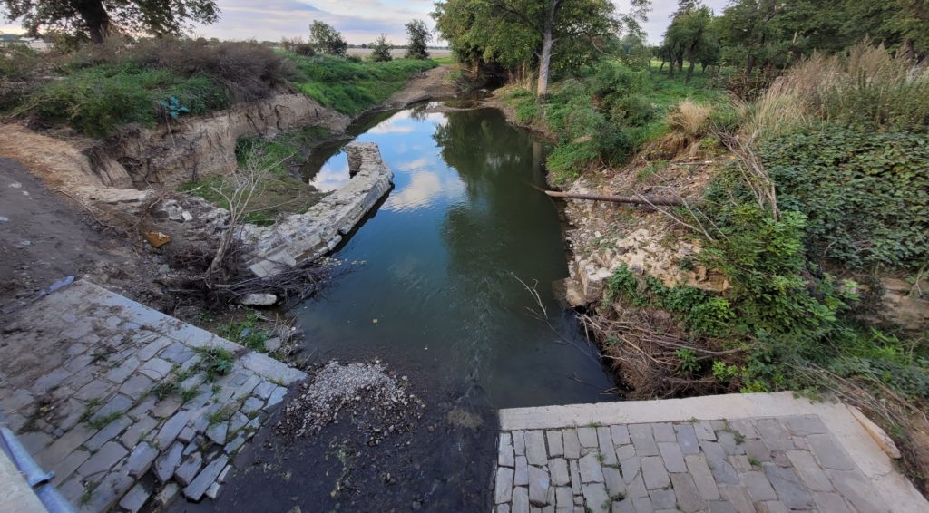
The project FloReST focuses on measures to increase the resilience of urban infrastructure in case of heavy rainfall and flash flood events. The aim is the development of innovative, technology-based solutions for a load-dependent and -independent evaluation of emergency drainage routes. Overall, a “tool set” of “smart tools” is created, which allows a selection of technically innovative and future-oriented tools to be adapted for locally high-resolution planning and the evaluation of emergency drainage routes. In close consultation with pilot municipalities, trade associations and affected citizens, this opens up an intelligent, dialogue-oriented path to the sustainable implementation of measures for flood- and flash flood prevention in urban areas.
Objectives
A new robot-supported system with integrated positioning and measuring sensors is developed. Through 3D data acquisition of the inner-city infrastructure, it will enable the user to achieve a previously difficult acquisition of small-scale flow obstacles as well as breaking edges. The targeted implementation of measures for flood and flash flood prevention is made possible by the use of UAV drone technology and doping tests for the experimental evaluation of load-dependent emergency drainage routes. Furthermore, the use of artificial intelligence will enable us to identify emergency drainage routes in detail on larger spatial scales without the resource-intensive, detailed adjustment of hydraulic models. A geo data warehouse and a mobile app for citizen information and participation serve as providers of digital data and methods and in order enable collection of data and local knowledge of past heavy rain events from local stakeholders. A high level of interactivity and the fundamental inclusion of affected citizens are guaranteed by risk communication between the pilot municipalities and collaborators. In particular, risk communication aims at involving and activating groups in areas with high levels of social inequality.
Working packages (WP)
The central body for contact and communication is our funding agency – the Federal Ministry of Education and Research (BMBF). Regular project work meetings and annual status workshops with all project partners are organized. In project management, together with the collaborators, the BMBF draws up rules for continuous evaluation and monitoring of the project progress using appropriate control and monitoring instruments.
In close cooperation with trade associations and pilot municipalities, various requirements for the smart tools are being developed and their practicality and transferability are constantly being evaluated. Various methods for determining emergency drainage routes are compared and a guideline for potential users is created. Flash flood-related risks and risk point information are determined and based on these, measures to identify emergency drainage routes are evaluated
Current techniques for recording terrain information are used and the recorded information is processed in a task-specific manner. Based on this, an innovative concept of a robot-supported system with integrated positioning and measuring sensors will be developed and tested in the pilot municipalities. The aim is to create a spatially high-resolution data base and a practical processing of the data for the planning of water-sensitive structures. This creates significant added benefits compared to established technologies.
State-of-the-art methods (2D hydraulic-numerical modelling and digital terrain models) for the identification of emergency drainage routes are applied and supplemented by innovative machine learning approaches for the development of a data-driven AI-efficient method. The use of UAV drone technology, thermal remote sensing and doping tests for the experimental evaluation of load-dependent emergency drainage routes enables a targeted planning and implementation of measures for flood and flash flood prevention at locations with a local risk of flooding.
All data used, acquired, and created in the project, shall be integrated in a Geo Data Warehouse. This will offer data interfaces and visualizations for different target groups with their specific decision-support needs. A mobile app shall both foster citizen participation and enable data acquisition through citizen science.
Sensitising and informing the population about the risks of extreme water events and the associated potential for action. Furthermore through multi-layered communication and participation of the potentially affected actors with the collaborators, suitable strategies to prevent and reduce potential damage are being developed.
Coordinator:
Prof. Dr.-Ing. Lothar Kirschbauer
Hochschule Koblenz
Associated Partners:
Stadt Trier, VG Altenahr, VG Linz am Rhein, VG Herrstein/Rhaunen, VG Mendig
Kompetenzzentrum Hochwasservorsorge und Hochwasserrisikomanagement (KHH)
- Landesamt für Umwelt RLP (LfU RLP)
Informations- und Beratungszentrum Hochwasservorsorge RLP (IBH)
- Ingenieurkammer RLP
Project period:
01.02.2022 – 31.01.2025
